I agree to and consent to receive news, updates, and other communications by way of commercial electronic messages (including email) from Durango Resources Inc. I understand I may withdraw consent at any time by clicking the unsubscribe link contained in all emails from Durango Resources Inc.
Durango’s copper claims are in the Babine copper-gold porphyry district of the north central region of British Columbia. The entirety of the Babine project now consists of 4 claim blocks totaling 4,635 hectares, including 2,303 hectares directly west and adjoining the western claim boundary of American Eagle’s NAK project (TSXV-AE) who encountered significant drill intervals of high-grade gold and copper mineralization. Notably, drill hole 23-17 returned 302m @ 1.09% CuEq on the western portion of the NAK property less than 2km from the eastern border of Durango’s Babine West Property.
The Babine Copper Projects are in the Omineca Mining Division of British Columbia, approximately 80 kilometres north of Smithers. The Babine Region is one of BC’s most prolific porphyry copper gold belts and includes past producing mines such as the Bell and Granisle as well as the Morrison copper gold deposit, American Eagle’s NAK project, and Amarc Resources’ Duke project. Infrastructure in the region consists of all-season roads, highway 16 and railway. Claims maps of the Company’s Babine project relative to neighbors and the area are included below (Figures 1, 2, 3.)

![]()
Fig. 1 - Babine area map
Durango is encouraged by the historical work and copper-gold porphyry discoveries of both American Eagle and Amarc Resources in the area. Historical work on the Company’s claims is also encouraging, as can been seen in a brief summary of these areas, also below. Durango recently visited the properties this fall to prospect the claims, confirm historical minfile showings, and collect samples. The Company obtained rock samples from each of the Company’s Babine claim areas and will be submitting them for assay.
Meanwhile management is currently reviewing all available data on each of these claims in the interests of devising a modern exploration program and advancing them as soon as possible.

![]()
Fig.2 - Babine Area Claim Map with NAK and Duke Projects
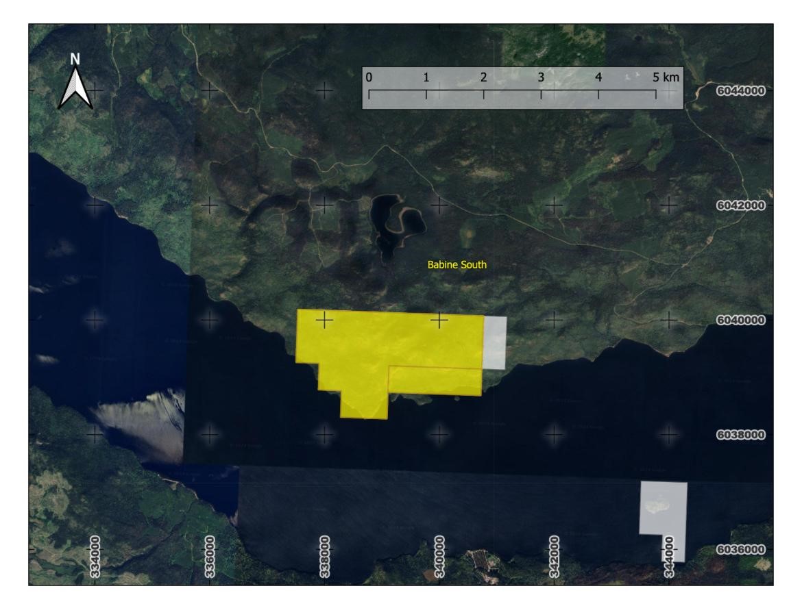
Babine West
2,303 hectares
The Babine West property covers three mineral claims and is bordering the west side of American Eagle’s NAK property (TSXV-AE) and borders Amarc Resources’ Duke Property (TSXV-AHR).
American Eagle has encountered significant drill intervals of high-grade gold and copper mineralization at NAK. Notably, drill hole 23-17 returned 302m @ 1.09% CuEq on the western portion of the property not far from the eastern border of Durango’s Babine West Property.
Amarc’s Duke Property covers 722km2 in the “DUKE District”, which hosts the DUKE Deposit, which is open to expansion, and includes a series of deposit-scale exploration targets.
The geology of the Babine West claims consists of a granodiorite stock containing phases of quartz monzonite and hornblende biotite feldspar porphyry of the Eocene Babine Intrusion. These cut grey, locally graphitic siltstones of the Middle to Upper Jurassic Ashman Formation. Stratified intermediate composition tuffs and/or greywacke and mudstone with minor silicification and some graded sandstones occur locally. The units are locally and strongly fractured and cemented with quartz and/or pyrite. Thus far pyrite has been identified in six outcrops and chalcopyrite in one.
Babine North
717 hectares
The Babine North property covers the historic Friday Red copper Minfile showing and is located 90 kilometres east of the community of Hazelton. The geology consists of gently dipping volcanic rocks and minor interbedded mudstones of the Lower Jurassic Telkwa Formation (Hazelton Group) which are intruded by a highly magnetic feldspar porphyry dike, possibly related to the Eocene Babine Plutonic Suite. Some minor amounts of chalcopyrite are disseminated in the matrix of amygdaloidal unit of volcanic rocks, at the showing.
Babine East
1,144 hectares
The Babine East Property is situated along the west side of the northwest arm of Takla Lake and covers the historic Minfile Adda showing. The area is underlain by volcanics and minor sediments. A few veins of chalcopyrite of 5-7.6 cm in width and some narrow chalcopyrite seams were observed in andesite (intrusive igneous rock) just above the lakeshore and sections of the chalcopyrite assayed 5.49 g/t silver and 10.6% copper with trace gold (Minister of Mines Annual Report, 1920, page 149).
![]()
Fig.3 - Babine South Claim Map
Babine South
470 hectares
The Babine South Property covers the historic Minfile Bol showing and is located on the north side of Babine Lake. The area of the Bol showing is underlain by Cache Creek Group greenstone. The mineralization occurs in quartz carbonate veins and shears within foliated greenstone. Mineralization consists of argentiferous galena, sphalerite, tetrahedrite, argentite, chalcopyrite, native silver, pyrrhotite and pyrite. Work on the property began as early as the 1920’s and about 94 kilograms of silver was produced (based on $1,000 of native silver at $0.33 per ounce) from a trench on the property. In 1991, the “silver pit” located near the east adit was re-opened to confirm the presence of high-grade native silver. A sample from this zone returned 26,000 grams per tonne silver and 0.82 per tonne gold (assessment report 22157). Sampling (Con-10-91) of a mineralized, 3- to 5-centimetre wide, quartz carbonate vein associated with a diorite dike located near the West adit assayed 2,790 grams per tonne silver, whereas a sample (Con-12-91) from a mineralized, 2- to 25-centimetre wide, vein in the West adit yielded 175 grams per tonne silver (Assessment Report 22157).
None of the historical information has been verified yet by the Company and should not be relied upon.
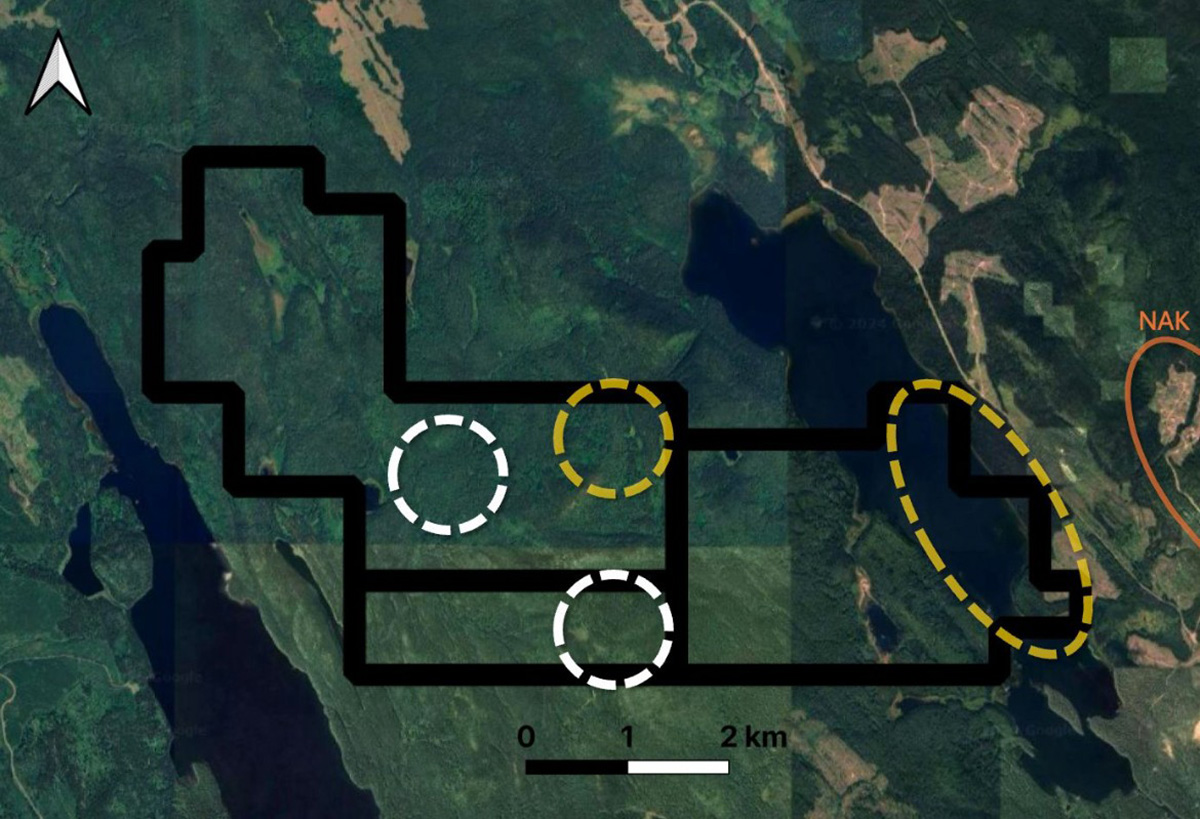
![]()
Fig.4 - Babine West Four locations of possible deep alternation, based on ExploreTech’s processing of historical geophysics data.
(Gold is from study area 1, white is from study area 2)
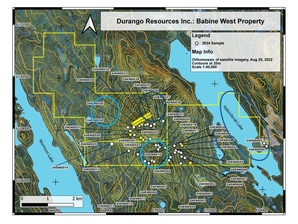
![]()
Fig.5 - Babine West AI areas of possible alteration and field rock sample locations.
Babine South
The Property covers two mineral claims, is approximately 470 hectares in size (see Figure 1), and hosts past producing silver adits from the 1920’s to 1930’s. The work history reports 94 kilograms of silver being produced from a trench, while two adits were completed to intersect the mineralization and a vein with silver rich galena was reported at 122 meters. One rock sample collected in 1991 reported 0.5% antimony along with 0.79% copper, 26.3% lead, 28.9% zinc, and 10.1 oz/t silver (Geological Assessment Report 21284).
The area is underlain by Cache Creek Group greenstone where mineralization seems to occur in quartz-carbonate veins and shears within foliated greenstone (amphibolite). Historically, the mineralization consists of argentiferous galena, sphalerite, tetrahedrite, argentite, chalcopyrite, native silver, pyrrhotite and pyrite. Tetrahedrite is an antimony rich mineral. The region also contains ultramafic rocks, such as peridotite, pyroxenite, and dunite which are rock types that can host nickel and platinum group element (“PGE”) mineralization.
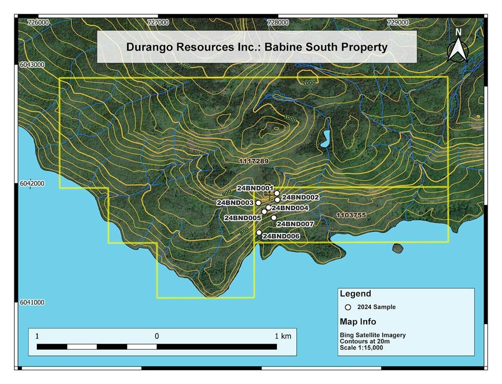
![]()
Figure 1. Location of Durango’s Babine South Property Sampling
Babine South Sampling Program
A field mapping and sampling program was completed in the fall of 2024 and seven (7) samples were collected from outcrop and float/scree in this program. The sampling included returns as high as 3.39 grams per ton (“gpt”) gold, 1% copper, 3430 gpt or 110.3 oz/t silver, 8.04% lead, and 8.86% zinc.
Samples underwent fire assay and ICP-OES and/or ICP-MS multi-element analysis. Table 1 below summarizes sample locations, lithology and assays. The sampling program was concentrated in the southern portion of the claim and the claim boundary has been expanded to the north since the surface sampling program was completed. Marked as white dots on Figure 1, all samples returned anomalous results from Babine South as detailed below:
- 24END001 – Quartz carbonate w chalcopyrite & galena (outcrop) – 143 gpt or 4.6 oz/t Ag, 0.28% Cu, 0.89% Pb, 1.26% Zn
- 24END002 – Quartz w chalcopyrite (float) – 3.39 gpt Au, 3090 gpt or 99.4 oz/t Ag, 0.86% Cu, 8.04% Pb, 8.86% Zn
- 24END003 – Rusty quartz w chalcopyrite & galena (float) – 300 gpt or 9.6 oz/t Ag, 0.38% Cu, 2.26% Pb, 2.41% Cu
- 24END004 – Diorite w rusty quartz carbonate (tailings float) – 3370 gpt or 108.4 oz/t Ag, 0.3% Cu, 3.44% Pb, 1.73% Zn
- 24END005 – Diorite w small quartz stringers (outcrop) – 3430 gpt or 110.3 oz/t Ag, 1% Cu, 7.95% Pb, 8.34% Zn
- 24END006 – Rusty vuggy quartz with chalcopyrite (float) – 89 gpt or 2.9 oz/t Ag, 0.44% Cu, 3.20 Pb, 1.73% Zn
- 24END007 – Rusty quartz with chalcopyrite (outcrop) – 3180 gpt or 102.3 oz/t Ag, 0.74% Cu, 6.98% Pb, 3.03% Zn
Geological and Technical Interpretations and Future Plans
The Company believes that the exceptional silver grades at Babine South indicate the potential for an epithermal polymetallic deposit. These deposits form when hot, acidic fluids from volcanic activity mix with groundwater at shallow depths, leading to the concentration of valuable minerals. Epithermal deposits are known for their high silver grades and are often associated with gold, lead, zinc, and copper, enhancing their economic potential.
About the Babine South Silver Zinc Project
Durango’s Babine South property covers two mineral claims and is approximately 470 hectares. The geology of the Babine South project area includes phyllite, marble and dioritic and monzonitic volcanic rocks. The region also includes ultramafic rocks, such as peridotite, pyroxenite, and dunite which are rock types that can host nickel and PGE mineralization. Four phases of veining run through the area and are cross cutting. The deposit is thought to be epithermal however historically there was some association of the veining with the foliation and shear zones. Mineralization includes quartz-carbonate veins including native silver, galena, sphalerite, tetrahedrite, argentite, chalcopyrite. MINFILE Mineral Inventory